The Flow of Seiders Springs
November 20, 2017 | By Shoal Creek Conservancy
Written by SCC Intern Randy Peterman
As an intern at the Shoal Creek Conservancy, one of my first projects has been to compile all known water quality and flow data on Seiders Springs (pronounced cedars). The springs are located on the east side of Shoal Creek in between 34th Street and 38th Street, and when I first visited them in September I was pleasantly surprised by their serenity and their quiet beauty. I could not help but marvel at this gem hidden away at the head of the Shoal Creek Hike and Bike Trail, routinely passed by Austenites on their daily commute and by visitors to the nearby Seton Medical Center. Perhaps its hidden gem status has contributed to the fact that it has been difficult for me to find historical information on the flow and water quality of the springs.
It is, however, commonly known that the springs flow from artesian pressure out of a fault in limestone. This means that the pressure at the fault is less than the pressure in the underground aquifer from which the springs originate, so the water flows from the aquifer out of the limestone outcropping and eventually into Shoal Creek. The flow of water from the springs can be impressive, although it may have been even more substantial 200 years ago.
As a whole, spring flow in Texas has decreased over the past two centuries due to human activity. Deforestation by Spaniards colonizing Texas and overgrazing by the livestock they brought with them compacted the soil, so it became more difficult for rainwater to recharge groundwater that fed the springs. Recent urbanization and associated impervious cover have contributed to this problem as well.
Spring flow in Texas has also decreased due to wells that settlers constructed in the 1800s and due to groundwater pumping for agricultural and municipal purposes, which lowered the water table and decreased underground pressure driving spring flows. Essentially, springs in Texas have taken a one-two punch: less water to supply the springs, and less force pushing the water out of the springs.
It is unclear to what extent each of these factors has contributed to a decline in the flow of Seiders Springs (if at all). Data and individual accounts on the flow of water in the springs are few and far between. We do know however, that in the late 1800s Edward Seiders ran a very popular bathhouse in the area that was filled by the springs, and Gunnar Brune reports in Springs of Texas that the springs “were described in 1839 as ‘a stream of limestone water which could be used as a water supply for the new capital.’ ”
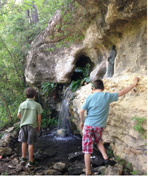
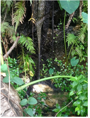
Water in the northernmost spring is almost always running, in contrast to the southern spring (shown in the photo to the left), which flows intermittently. This has led some to hypothesize that although these springs are collectively known as “Seiders Springs,” they may be two completely different springs that take their water from completely different sources.
In fact, the southern spring is very unique – there is no other in Texas like it. When it releases water it will sometimes exhibit an ebb-and-flow behavior within a period of about five minutes. It will occasionally alternate between a small trickle of about 2 to 7 gallons per minute and a gush of water between 50 and 62 gallons per minute. This cyclic action may be caused by siphoning in the limestone fault where the water comes from, but further examination is needed to confirm this and understand exactly how and when this process happens.
Both this article and my research have barely touched on the rich history surrounding Seiders Springs. I have been slightly more successful in collecting historical water quality data for the springs, but there are still large periods of time in which there appears to be no information recorded. This lack of information adds a touch of mystery to this secluded natural wonder. The Springs are definitely worth a visit for lovers of nature, science, history, and the unknown.
If anyone has any information about the water quality or flow of Seiders Springs that they would like to share, feel free to email [email protected] – it would be greatly appreciated!
Sources:
http://www.health.state.mn.us/divs/eh/wells/waterquality/springs.html (original source link broken)
https://www.health.state.mn.us/communities/environment/water/wells/waterquality/springs.html
http://www.eahcp.org/documents/1981_Brune_TexasStreams4.pdf (original source link broken)
https://books.google.com/books?id=bvJ6gjatcK0C&printsec=copyright#v=onepage&q&f=false
https://www.twdb.texas.gov/publications/reports/numbered_reports/doc/R189/R189.pdf
Personal communication with geoscientist Jeff Henke
